Echoes at Dawn Mine
By Jake Brouwer
One Sunday afternoon while skimming
through newspaper clippings about the Mt. Lowe area, I came
across an interview a reporter had with a conductor of the
scenic railroad. The conductor, from memory, proceeded to
recite his spiel and so the reporter wrote it down.
A part that particularly caught my
attention went like this; "We have now passed
around the Cape of Good Hope and are entering Millard Canyon.
Just ahead is the longest stretch of straight track on this
section of the trip. It is 225 feet long. Millard Canyon
below you now is a beautifully wooded canyon with a small
stream at the bottom. Below us in the canyon at this point is
the Dawn Mine, an early-day gold mining venture. Several of
the tunnels still remain but are boarded up and used as part
of Pasadena’s water supply system."
 Well, now that opened my eyes. A gold mine in
Millard Canyon, imagine that. Once upon a time I prospected
around Randsburg, the Cajon Summit and the East Fork of the
San Gabriel River, moving on only to research more about our
Mt. Lowe Railroad. Now the railroad seemed to be bringing me
back to my golden beginnings.
Well, now that opened my eyes. A gold mine in
Millard Canyon, imagine that. Once upon a time I prospected
around Randsburg, the Cajon Summit and the East Fork of the
San Gabriel River, moving on only to research more about our
Mt. Lowe Railroad. Now the railroad seemed to be bringing me
back to my golden beginnings.
The Dawn Mine District is located in the
southern part of the San Gabriel Mountains, which separate the
Southern California basin on the south from the Mojave Desert on the north. Its
boundaries are Eaton Canyon on the East, Bear Canyon on the
North, Arroyo Seco on the West, and to the south of Altadena. The
entire district covered roughly sixteen square miles and is some
of the most rugged terrain in the region. The area reached its
current elevations by several stages of uplifts since the late Pliocene time. In the southern
extremities of the San Gabriels the elevations range from one
thousand to two thousand feet, while in the northern end the
height of 6152 feet is reached at San Gabriel Peak.
 The Dawn Mine District was
compromised of four mines, Saucer Canyon Mine, Dawn mine, Eagle
Lutch Mine and Upper Dawn Mine. The first three of these mines
were all located on the same vein, the main ore body being about
two miles long. Saucer Canyon Mine being the first along the vein
in the small tributary of Millard Canyon. Here the surface shows
the appearance of a hematite in quartz vein, dark brown to red in
color 100 feet in width. The brave miner that operated this claim
had his cabin suspended in the air by steel cables which held it
against the face of a sheer rock wall. The auriferous vein of the
Eagle Lutch Mine is at the upper end of the first ravine to the
west of Las Flores Canyon. It is believed to be a branch of the
main vein that heads in a southwesterly direction from just above
the Dawn Mine. The Upper Dawn Mine is located on the south side
of the trail from Dawn Mine to Switzer-land, about one and
one-half miles north of the Dawn Mine.
The Dawn Mine District was
compromised of four mines, Saucer Canyon Mine, Dawn mine, Eagle
Lutch Mine and Upper Dawn Mine. The first three of these mines
were all located on the same vein, the main ore body being about
two miles long. Saucer Canyon Mine being the first along the vein
in the small tributary of Millard Canyon. Here the surface shows
the appearance of a hematite in quartz vein, dark brown to red in
color 100 feet in width. The brave miner that operated this claim
had his cabin suspended in the air by steel cables which held it
against the face of a sheer rock wall. The auriferous vein of the
Eagle Lutch Mine is at the upper end of the first ravine to the
west of Las Flores Canyon. It is believed to be a branch of the
main vein that heads in a southwesterly direction from just above
the Dawn Mine. The Upper Dawn Mine is located on the south side
of the trail from Dawn Mine to Switzer-land, about one and
one-half miles north of the Dawn Mine.
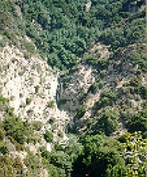
The main mine of the district was the Dawn
Mine. Dawn is deep in the folds of Millard canyon whose walls
rise 1000 to 1500 feet. Access was gained to the area by way of
Millard Canyon Trail or from above by means of the Scenic Mt.
Lowe Railroad. From Millard Canyon it is a pleasant two and one
half-mile trip.
This prospect is said to have been found by a
Spaniard, though I would venture to guess it was known earlier by
the Gabrielino Indians of the area. The first owner of record was
Bradford Peck. Peck had come from the Randsburg Mines where he
was partners with a man named Ehrenfeld, whose daughter Peck was
quite fond of. Her name was Dawn and hence the Dawn Mine was
named. Peck operated the mine for a number of years with limited
success. Although a minor gold rush of sorts was occurring in the
area the booming explosions of
men blasting their way through granite while creating the Mt.
Lowe railway bed overshadowed the mining ventures.
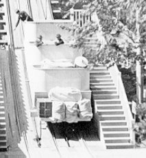
On July 10 1902 an experienced miner from
Australia, Michael T. Ryan purchased the Dawn Mine. Ryan extended
the tunnels further into the mountain and actually ran a
profitable venture for a time. Ryan built a narrow trail that
switched back numerous times up the steep walls of Millard Canyon
to where it met the Alpine division of the narrow gauge railroad.
Ryan’s two faithful and sure-footed burros were
appropriately named Jack and Jill. Once having traversed the
precipitous trail the mules had their load of ore transferred to
a railroad car where it was eventually brought down to Echo Mt.
and then lowered again by way of the great incline to Rubio
Canyon and finally brought to market. Assays at the time put the
sulfide ore of the major vein at $25.-27.00 a ton while the
limonite ore from a lessor ore ran $13-17.00 per ton.
 The Pacific Electric Railroad,
owners of the Scenic Mt. Lowe Railroad, built a station stop at
the top of the trail and called it Dawn Station. For a time the
trolley would stop at Dawn Station and the adventurous tourists
riding the rails would tramp down to the lower reaches of the
canyon to visit the workings of the gold mine. This became a
problem for the railway as the arduous trek back up caused
numerous delays. I’m told that someone had a phony gold mine
built just a ways down the trail to avoid future delays.
The Pacific Electric Railroad,
owners of the Scenic Mt. Lowe Railroad, built a station stop at
the top of the trail and called it Dawn Station. For a time the
trolley would stop at Dawn Station and the adventurous tourists
riding the rails would tramp down to the lower reaches of the
canyon to visit the workings of the gold mine. This became a
problem for the railway as the arduous trek back up caused
numerous delays. I’m told that someone had a phony gold mine
built just a ways down the trail to avoid future delays.
By 1927, according to the Report of the State
Mineralogist the Dawn mine was idle. Perhaps Ryan was ill, as it
was two quick years later that Michael T. Ryan died. Ryans widow
let several miners work the claims until 1933.
 At that
time Ryan’s wife leased the mine to a group headed by L. L.
Hunter, H. L. Comstock, and L. L. Hilton. The group invested
large sums of money boring new tunnels into the mountainside
bring the total workings to a distance of 1200 feet. In 1935
after an extremely wet season washed out some of the Mt. Lowe
Railroads track, the Hunter group built a small mill site
one-half mile downstream from the mine. At the mill there was a
grizzly with one inch openings; elevator to small bin, two
vibrating screens, 20 and 30 mesh; oversized to combined crusher
and rolls, followed by one sand and one slime table. It took four
men to work the mill site.
At that
time Ryan’s wife leased the mine to a group headed by L. L.
Hunter, H. L. Comstock, and L. L. Hilton. The group invested
large sums of money boring new tunnels into the mountainside
bring the total workings to a distance of 1200 feet. In 1935
after an extremely wet season washed out some of the Mt. Lowe
Railroads track, the Hunter group built a small mill site
one-half mile downstream from the mine. At the mill there was a
grizzly with one inch openings; elevator to small bin, two
vibrating screens, 20 and 30 mesh; oversized to combined crusher
and rolls, followed by one sand and one slime table. It took four
men to work the mill site.
The Hunter group developed and sunk a wince 55
feet on the vein 3-4 feet wide. The ore values in this wince are
said to be $20-30.00 per ton. A raise was also put in to connect
with an upper tunnel where the vein is said to reach five feet in
width and contain better values. One year the team hit a kidney
pocket, which yielded $3400.00. Although values were better and
occasional good pockets brought prolonged dreams of riches, the
team’s small profits went to larger losses. Building the
mill and other expenses simply ate up all hope of making a
profit.
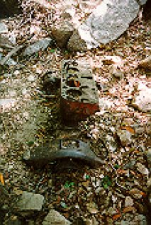 By the time the Mt. Lowe Railroad made its last run in
December of 1937 new trails were built for hauling the ore out
and at one time a couple of Model T Fords were even used.
Just below the mine entrance lying in the streambed half buried
in the gravel’s lies an engine probably used for this
purpose.
By the time the Mt. Lowe Railroad made its last run in
December of 1937 new trails were built for hauling the ore out
and at one time a couple of Model T Fords were even used.
Just below the mine entrance lying in the streambed half buried
in the gravel’s lies an engine probably used for this
purpose.
The demands of World War II cut off much of the
powder and other essentials needed for mining and operations were
brought to an end.
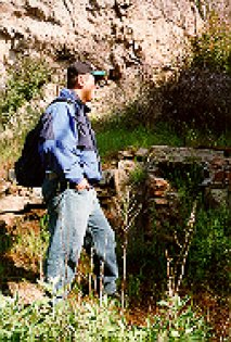
A wooden door was placed across the opening of
the mine tunnel but it has failed to keep out impetuous explorers
of the dark and damp hazard. In 1954 the sheriff at the time,
Pete Sutton, made an inspection of the mine and recommended that
the openings either be dynamited closed or the openings be closed
in by steel doors set in concrete. The owner at the time a C. H.
Finlayson of Hawaii was contacted in
regards to the matter but we can assume to no end as the mine
lies unprotected to this day.
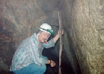
This writer strongly suggests that
you stay out of this mine. It is dangerous and not for the
faint of heart. The exploration of mines should be set aside
for the professional and not taken lightly. Hiking to the
Dawn Mine is another matter. It is a beautiful trek to a
historic site that can easily be done in half a day. Read
further on in this issue to HIKING MT. LOWE TRAILS. Also
check out the segment about MINE DANGERS.
Send email to Echowebmaster@aaaim.com to report any problems.
Last modified: February 12, 1999
No part of this paper may be
reproduced in any form without written permission from:
Jake Brouwer
All articles and photos were provided by:
Land-Sea Discovery Group
Copyright © 1999