 |
| Navigation Through The Angeles National Forest |
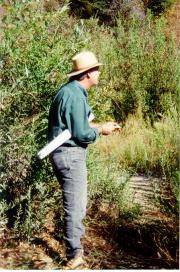
Generally speaking, you won’t be walking in many straight lines in the Angeles National Forest. Your best bet is to study the maps, and then stay on existing trails. The trails are usually the easiest route from one site to another, though not necessarily the shortest route "as the crow flies." These "easier" routes tend to meander around hills and through canyons, giving you the least elevation gain from point to point.
NATURAL NAVIGATION
There are many natural observations that we can make in the Angeles National Forest which help us determine direction. However, one can't rely on just one of these signs because there are always local exceptions to the general rules.
For example, we've all heard that moss grows on the north side of trees, right? But is that a fact? When I was in high school, I took a few backpacking classes conducted by Abby Keith of the
Sierra Madre Search and Rescue team.. He would tell us, "Yes, moss grows on the north sides of trees .... and the east side, and the west side, and the south side." We'd all laugh, and he would point out that in a dense forest, moss can grow entirely around a tree, and that the value of moss as a direction finder is very limited. Keith would say, however, that if you are looking at a pine tree with moss on one side, in a clearing, in California, then the moss is probably on the north half of the tree.Another natural observation states that if you press the palm of your hand onto a tree, the hot side of the tree is generally south, and the cool side of the tree is generally north.
Still, the value of such information is somewhat limited.
For example, we’ve often heard such pearls of wisdom as "all streams will eventually flow to civilization." Thus, if you get lost, all you need to do is follow a stream. Well, that works some of the time. The problem is that there are some treacherous waterways in the Angeles Forest’s canyons. Some of the streams pass over rocky falls and steep waterfalls. Some won’t lead you back down to the city, but will simply lead you east or west deeper into the forest.
Again, stay on the trails. If you don’t go cross country, you’ll stay out of trouble.
There is a great wealth of weather lore and nature observations which give you indications about directions. The best book I’ve seen on this subject is Wildwood Wisdom by Ellsworth Jaeger.
NAVIGATION BY THE SUN
There is a simple way to determine the approximate time by the sun. When I was first told about this method, it was referred to as a "
Navajo" method of reckoning time. I have since heard it attributed to at least a half-dozen other Indian tribes, probably due to the fact that this was somewhat universally practiced by Native Americans. |
In fact, this method doesn't actually tell time. Rather, it tells you how many hours you have left until sunset.
Let’s assume that it’s late afternoon. Face the western horizon and stretch out your hand to the sun. Keep your arm straight but bend your hand so that your palm faces the sun and your fingers are horizontal. Tuck in your thumb. Align the top of this hand with the sun, and then bring each hand below the other in this fashion until you reach the horizon. Interestingly, four fingers equals just about the space that the sun travels in an hour. Thus, you can ascertain how many more hours until sunset, or -- in ancient terms -- how many "hands" until sunset.
For directions, pioneers and Indians have long resorted to driving a stake into the ground. This would be done on flat ground on a sunny day. They would mark the end of the stick's shadow with a pebble. After a short while, they would place a second pebble at the tip of the new shadow. A line drawn between these two pebbles produces a fairly accurate east-to-west line.
NAVIGATION BY THE STARS
Night navigation brings with it a whole new set of problems and challenges.
If there is a full moon it may be an ideal time to travel. This is a unique opportunity to see the Forest in a wholly new light. In an emergency, when you may need to travel at night, a full moon will be most appreciated.
In the Northern Hemisphere, the North Star is probably the single most important star that you should learn to identify. It is not, however, the brightest star in the sky.
The North Star is located by first finding the Big Dipper, a group of seven stars formed like a bowl and handle. The bowl of the Big Dipper has two bright stars which are often referred to as the pointer stars because they lie in a straight line with the North Star. The distance to the North Star from the two pointer stars is approximately five times the distance between the two pointer stars.
There are many other easily-recognized groups of stars that are worth learning to identify. The best book on this subject that I've found is The Stars by H.A. Rey.
Keep in mind that if you are deep in a canyon, you probably won’t see the North Star at all because hills to your north may obscure it. This is why it is wise to become familiar with other constellations as well.
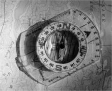 |
NAVIGATION WITH A MAP AND COMPASS
I won't kid you here. To truly master the use of a map and compass, you owe it to yourself to enroll in a college course, or purchase a good book on the subject. The best, in my opinion, is Be Expert With Map and Compass by Bjorn Kjellstrom.
When you purchase a compass, you usually get a few pages of fine print describing how to use that particular compass, and how to use a compass in general. Read that literature until you understand it well enough to be able to describe it to someone. This is very important.
I recommend an orienteering compass by Silva or Suunto, with a rectangular clear plastic base, and a round movable housing. Usually, it comes with a cord so you can wear it around your neck. As you become more experienced with using a compass, you’ll find that many of the more expensive models with their specialized features can be quite useful. But for starters, you only need a simple compass.
Keep in mind that, due to the ruggedness of the Angeles National Forest, you could do fine if you never carry a compass as long as you stay on existing trails. A map, of course, is always a good idea. And if you don’t intend to put in the time to learn how to use that compass, then leave it at home! It is of extremely limited value if you can’t use it.
If you do get lost, some of the methods discussed here may help you re-orient yourself.
GLOBAL POSITIONING SYSTEM?
Global Positioning System (
GPS) is a method for determining your location based on data from satellites. You use a small device (it looks like a small calculator) which gives you co-ordinates to your local topographical map.Rich Hawkins, District Fire Management Officer with the Angeles National Forest, highly recommends this system if you travel a lot. "This is especially valuable when you’re in an area for the first time and don’t know the terrain," says Hawkins. He explains that GPS allows you to determine your location, where you should go, and how to find your way back, even in the fog or dark. "You should not get lost if you have one of these devices," explains Hawkins. In order to use this properly, you need to understand latitude and longitude on a world map and you should expect to invest about three to four hours of field practice -- which is about the same amount of time it takes to learn to use a compass.
Though there are several manufacturers of GPS devices, Magellan devices are the most popular among Forest Service workers. A Magellan GPS device costs about $300. Though it takes about as long to learn to use a GPS devise as it takes to learn to use a compass, the GPS devise is significantly more expensive and very high-tech. They work because of information beamed to earth from satellites. For some applications, these expensive toys might be right for you. But with the growing concern over the Y2K problem, and the possibility that embedded chips in satellites could be affected, my inclination is to save my money and just get a good traditional compass.
Nyerges has been leading survival skills outings in the Angeles Forest since 1974. His books, Enter the Forest ($10) and Guide to Wild Foods ($17) are available in our Mountain Marketplace and at all Sport Chalet stores, or from the School of Self-Reliance, Box 41834, Eagle Rock, CA 90041, and on-line at www.self-reliance.net.
Send email to Echowebmaster@aaaim.com to report any problems.
Last modified: February 12, 1999
No part of this paper may be
reproduced in any form without written permission from:
Jake Brouwer
All articles and photos were provided by:
Land-Sea Discovery Group
Copyright © 1999